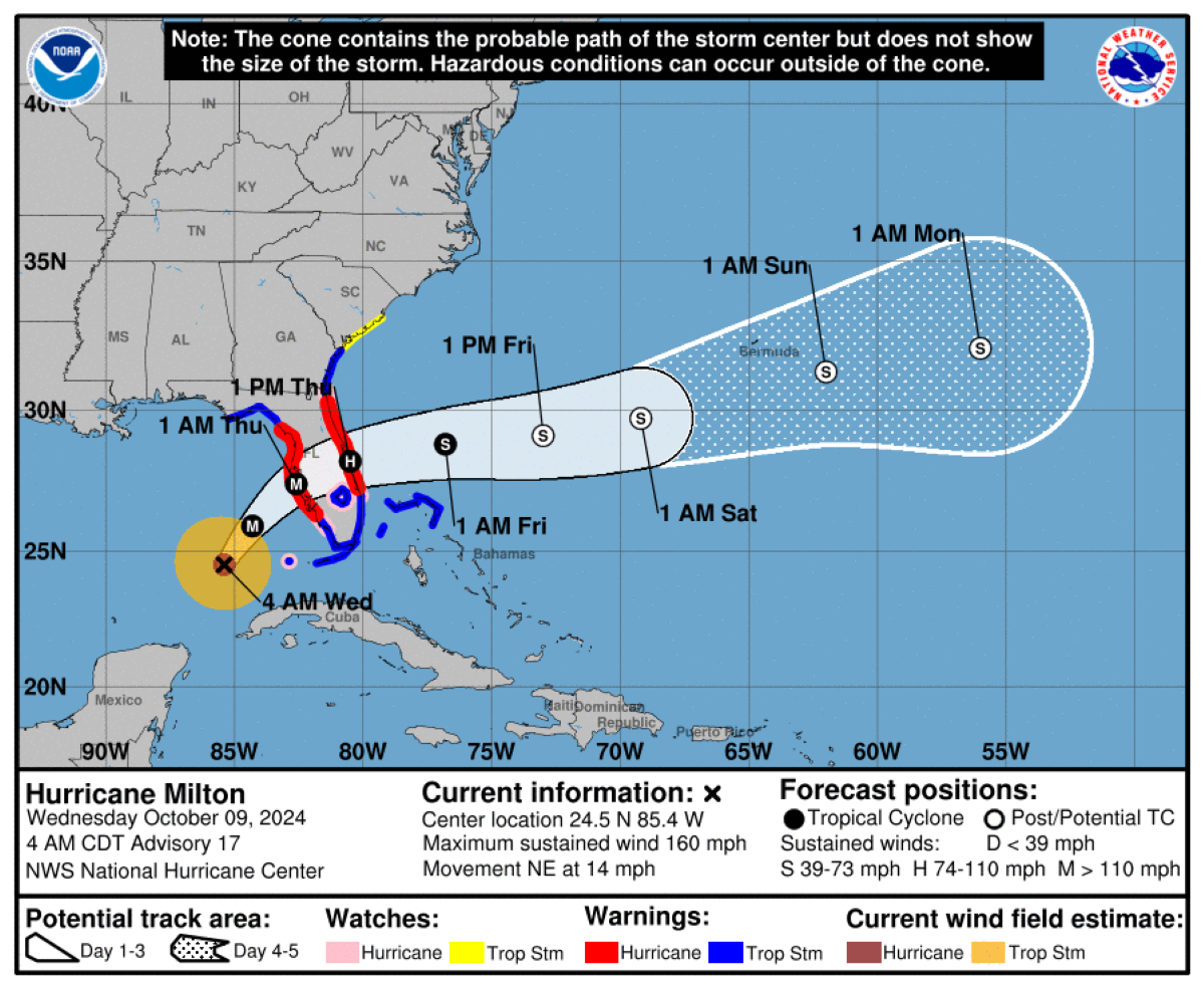
Hurricane Milton is making its way toward Florida’s Gulf Coast, with the powerful Category 5 storm now projected to strike near Sarasota, just south of Tampa Bay.
As of 2 a.m. Wednesday ET, the National Hurricane Center (NHC) reported Milton’s maximum sustained winds at 160 mph, moving northeast at a speed of 12 mph.
Initially, forecasts indicated Tampa as the likely landfall site, but recent updates point to Sarasota as the more probable location.
Where Will Hurricane Milton Make Landfall?
The NHC’s latest prediction, released Monday at 5 a.m., anticipated Milton’s eye passing over central Florida around 2 a.m. Thursday, with landfall expected near Tampa on Wednesday evening.
That afternoon, a further update estimated a landfall time of around 8 p.m. Wednesday.
The NHC’s latest forecast suggests the storm’s center will be just off Florida’s west coast at 7 p.m. Wednesday, transitioning directly over central Florida by 7 a.m. Thursday.
Florida Governor Ron DeSantis cautioned residents that the effects of Milton would reach far beyond the immediate landfall area. “We could see impacts anywhere from Citrus County down to Southwest Florida. The storm surge will affect areas regardless of where the eye touches land,” he emphasized.
Meteorologist Bryan Bennett noted that a Sarasota landfall instead of Tampa could mean a critical change in storm surge predictions. “Tampa Bay might not face a significant storm surge, potentially even experiencing some draining, unlike Sarasota, Siesta Key, Venice, and Englewood, which are bracing for over 10 feet of surge,” he explained.
Hurricane Milton’s Projected Path
Currently, the NHC has been closely monitoring Milton’s trajectory. The storm is expected to remain a hurricane as it travels across central Florida on Thursday before moving into the Atlantic Ocean north of the Bahamas.

A storm surge warning is in effect for Florida’s west coast from Flamingo to Yankeetown, including areas like Charlotte Harbor and Tampa Bay, as well as the Atlantic coast from Sebastian Inlet to Altamaha Sound in Georgia. Some regions may experience storm surges exceeding 10 feet.
A Hurricane Warning covers Florida’s west coast from Bonita Beach to the Suwannee River, alongside the Atlantic coast from the St. Lucie/Martin County line to Ponte Vedra Beach.
Current maps from the NHC reflect the areas under storm surge warnings.

The storm may make landfall as soon as Wednesday afternoon, although timelines have now been pushed back to the evening hours.
Hurricane Milton Evacuation Map
Mandatory evacuation orders are in effect for numerous counties, with additional voluntary evacuations issued elsewhere. Governor DeSantis has declared emergencies in 51 counties, urging residents to comply with evacuation orders and prepare for potentially severe impacts.
Evacuations are particularly crucial along Florida’s west-central coast, where storm surges may exceed 10 feet in some locations. An interactive map detailing evacuation orders for each county can be found on floridadisaster.org.
